|
 59.0°F
Cool
Wind Chill:
58.8°F
|
| Temp |
Highs |
Lows |
| Today: |
61.6°F
2:23pm |
38.2°F
6:34am |
| Yesterday: |
68.6°F
4:01pm |
38.5°F
6:45am |
| One Year Ago: |
64.5°F |
54.3°F |
| Station RecordOn This Date:4 |
75.2°F
2016 |
25.6°F
2014 |
| This Month: |
73.8°F
Apr 9 |
29.3°F
Apr 8 |
| Windsor LocksRecordOn This Date:5 |
95°F
2002 |
25°F
1908 |
| Normal:5
|
61 °F |
39 °F |

|
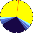
It is Day time
|

|
Wind:
WNW
5.0
Gusting to:
3.9
|
 |
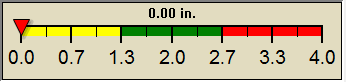
Rain:
0.00 in
|
Outside Temperature |
|
Last Hour:
|
-0.9°F
|
|
24 Hour:
|
-8.5°F
|
Outside Averages |
| MTD Average: |
47.6°F |
| YTD Average: |
37.1°F |
Inside Temperature |
| Currently: |
 68.7°F 68.7°F
|
| Last Hour: |
+0.1°F
|
|
This
Afternoon

Chance Rain Showers
|
Tonight

Rain Showers
|
Thursday

Rain Showers
|
|
Hi 61 °F |
Lo 43 °F |
Hi 47 °F |
1 Rain season: Jan 1st to Dec 31st.
2 Snow & heating degree day season July 1st to June 30th.
3 Snow manually measured, usually around 6PM.
4 Station high/low records for this date, exclusive of todays readings, since 2013.
5 Windsor Locks Record and Normal temperatures are at Bradley International Airport, Windsor Locks, CT and are updated at 4AM.
6 Overnight Frost calculation starts at 10AM and resets to zero at 10AM the next day.
10 Historical average only to day 17 of just the month of April for this station since 2012
11 Historical average rain this year to day 17 of April for this station since 2012 |
| NWS Weather Forecast -
Outlook This Afternoon & Tonight |
This
Afternoon
Chance Rain Showers
Hi 61 °F
|
NWS forecast: A chance of rain showers after 4pm. Cloudy, with a high near 61. South wind around 9 mph. Chance of precipitation is 30%. New rainfall amounts less than a tenth of an inch possible.
|
Tonight
Rain Showers
Lo 43 °F |
NWS forecast: Rain showers. Cloudy, with a low around 43. Southeast wind 6 to 10 mph. Chance of precipitation is 80%. New rainfall amounts between a quarter and half of an inch possible. |
|
| NWS Short Term Weather Forecast |
|
Thursday
Rain Showers
Hi 47 °F |
Thursday
Night

Chance Rain Showers then Cloudy
Lo 40 °F |
Friday

Mostly Cloudy then Chance Rain Showers
Hi 53 °F |
Friday
Night

Chance Rain Showers
Lo 44 °F |
Saturday
Chance Rain Showers then Partly Sunny
Hi 59 °F |
Saturday
Night

Mostly Clear
Lo 37 °F |
Sunday

Mostly Sunny
Hi 55 °F |
|
| Click here for Local 5-day Forecast
|
|